|
|
1985: Boulder County's Conservation Easement Program
Boulder County's Conservation Easement Program implemented in 1978, is a critical point in the evolution of the City of Boulder. It was adopted to build upon the 1978 Comprehensive Plan and placed value to preserve rural areas, develop in urban areas, while allowing urban centers room for growth. The Easement Program, in conjunction with the Comprehensive Plan has limited the capacity for sprawling development and kept spatial inequalities at bay. Boulder County, working with the City of Boulder, has significantly increased the amount of open space between 1975 and 2011.
|

70
|
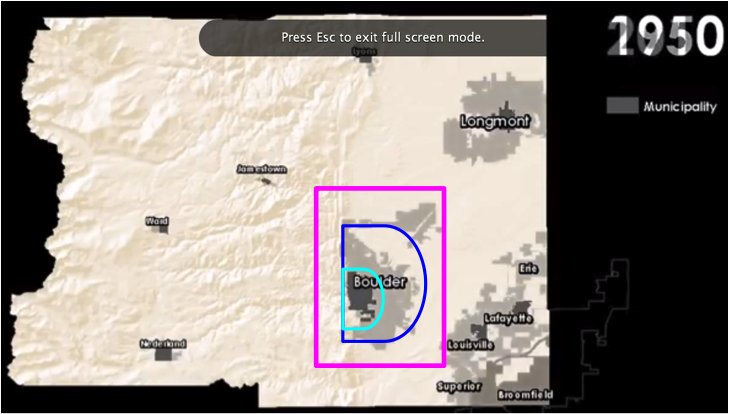
Put An Early Halt To Sprawl The 1985 Boulder County Conservation Easement Program was an early conservation effort that greatly shaped the city spatially. The Boulder County 1975 map illustrates the initial regional efforts to preserve the valuable landscape. It shows that the first targeted lands were surrounding Boulder's built-out city limits. By dedicating these lands to conservation, it greatly halted the ability of sprawl, which became a large concern to the residents with the opening of Highway 36. If sprawl was not limited on Boulder's part, a somewhat regional city could have been created- sprawling from Denver to Boulder. The lands in this program work as a growth boundary, which has prevented sprawl and preserved the urban form and density, and a vast amount of open space that is an attraction for all residents.
|

70
88
88
89
|
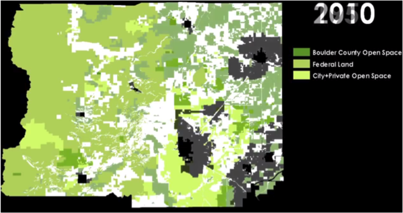
Contained The City The ongoing efforts are shown in the Boulder County 2011 map(on the left). The conservation easements and preserved open space now dominate the vast amount of Boulder County. As you can see, the City of Boulder is almost entirely surrounded by permanently undeveloped lands, which situate the city has 'true bound.' Meaning that the municipal boarder is also the actual boarder of the urban infrastructure.
Maintained The Urban Form The simulation to the left shows the change in the city boundary since its' inception. The light blue ring is the early boundary, which today contains the downtown and core of the city. The second ring, in darker blue, in the city boundary today. The pink outline is showing the general Boulder area.
This map (to the left) is at the same scale of the previous simulation. The map is illustrating the impact of the conservation efforts on development/growth. You can see that there is no longer much space for the city to expand into. The city's growth had radiated to the east because the west boundary was already deemed unfit for development because of the mountainous terrain. Moreover, the accumulation of open space prohibits the surrounding cities from expanding into each other, which saves the municipality resources and then only has to reinvest in the urban core.
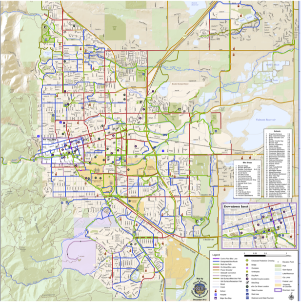
Ability To Reach More Residents Since the urban infrastructure has been preserved, more residents can access the city services than if the city had experienced sprawling effects. The transportation map shows that Boulder has made many efforts to ensure that the city is accessible, and without depending on the automobile. This reduces the occurrence of lower-income residents having a hindering commute to their jobs, if they are not able to live near them because of high prices. The accessibility is possible mostly because the city's boundary had been contained, and Boulder can reinvest in their current infrastructure.
|
